Vantor Wins NGA Luno B Contract to Deliver AI-Powered Global Change Detection
Vantor Wins NGA Luno B Contract to Deliver AI-Powered Global Change Detection
Vantor will integrate data from multiple satellite constellations and use an advanced suite of automated change detection capabilities to rapidly identify changes to the Earth’s terrain
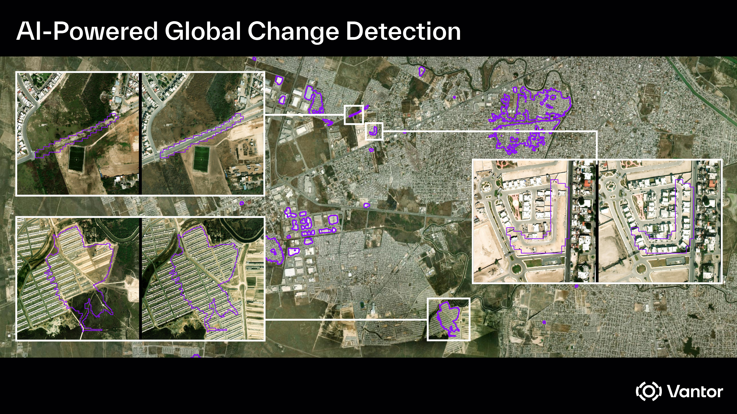
WESTMINSTER, Colo.--(BUSINESS WIRE)--Vantor, the leading provider of unified spatial intelligence from space to ground, has been awarded a $5.3 million National Geospatial-Intelligence Agency (NGA) Luno B contract to detect and deliver automated insights on real-time changes to the Earth’s landscape, strengthening NGA’s global mapping and intelligence missions.
Under the contract, Vantor will use AI-powered analytics and integrate data from multiple space-based sensors—including its own imaging satellites and third-party electro-optical and synthetic aperture radar (SAR) satellites—to identify changes to the Earth’s physical terrain.
The insights will drive updates to NGA’s comprehensive Land Use Land Cover classification system, which ensures the accurate characterization of land use and its condition worldwide. Vantor’s proprietary change detection models can identify shifts in key features—including buildings, roads, vegetation, and other land cover elements—across diverse sensor types and data sources.
Additionally, Vantor’s insights will be key to supporting NGA missions including, but not limited to, natural and man-made disasters, regional conflicts, and events that require humanitarian assistance by providing on-demand change detection.
“This win highlights Vantor’s unique capability to integrate the vast amount of data from multiple sensors to not only detect changes on a global scale, but to also deliver advanced analytics,” said Susanne Hake, Executive Vice President & General Manager, U.S. Government at Vantor. “We’re proud to continue to support NGA in delivering world-class GEOINT that provides a decisive advantage to policymakers, warfighters, intelligence professionals, and first responders from seabed to space.”
Vantor’s virtual constellation capabilities enable the company to seamlessly collect, process, analyze, and disseminate intelligence from multiple space-based sensors to create an AI-ready living globe, making it possible to support large-scale global monitoring and anticipate where maps and their features may require updates.
The Luno program—made up of Luno A and Luno B—is part of NGA’s ongoing efforts to execute an agile acquisition strategy that unlocks the capacity and innovation of the commercial geospatial industry.
In June, Vantor, formerly known as Maxar Intelligence, announced an NGA award under Luno A to deliver AI/ML-generated object detections to support persistent monitoring. Under the contract, Vantor is using its commercial Site Sentry capability, a global-scale persistent monitoring solution that enables customers to monitor hundreds of locations simultaneously. Site Sentry identifies assets across air, maritime, land, and rail domains; determines counts at specified locations; detects trends and anomalies; and supports advanced spatial and temporal geospatial intelligence analysis.
About Vantor
Vantor is forging the new frontier of spatial intelligence to unlock a more autonomous, interoperable world. We give decision makers and operators the power to build a unified intelligence picture, delivering the clarity they need to navigate what’s happening now and shape what’s coming next. We fuse data from the world’s most capable imaging satellites with real-time sensor feeds from space, air, and ground to create an AI-ready digital twin of Earth. Our spatial intelligence platform automates every part of the cycle—from tasking to collection to production—to update and analyze this foundation at the pace of change. Our products drive deeper mission-critical insights and connect the next generation of autonomous systems across the defense, intelligence, and commercial landscape.
Contacts
Jennifer Rizzo
Vantor
jennifer.rizzo@vantor.com