Esri’s ArcGIS Platform Chosen for Red Bull X-Alps Competition Live Tracking App by zooom Productions
Esri’s ArcGIS Platform Chosen for Red Bull X-Alps Competition Live Tracking App by zooom Productions
Agency Integrates Esri Platform as a Service for Real-Time Event Experience
REDLANDS, Calif--(BUSINESS WIRE)--Esri, the global leader in location intelligence, announced today that zooom productions, a marketing agency specializing in sports and lifestyle brands, is among the latest to select ArcGIS Platform, Esri's new platform as a service (PaaS). The agency has chosen ArcGIS Platform to provide Esri's World Imagery for a custom Live Tracking app that spectators can use to watch and track athletes’ experiences as they compete in the 2021 Red Bull X-Alps competition.
Spanning five countries along more than 1,000 km (775 miles) of challenging terrain along the Alps, the Red Bull X-Alps is the world’s toughest adventure race. It sees athletes compete for almost two weeks by foot or paraglider via a fixed set of turn points. Competitors are either trail running, hiking, mountaineering or paragliding.
“Thanks to ArcGIS Platform, we can offer a better, more enriched experience for spectators,” said Ulrich Grill, CEO of zooom productions and co-founder of the race. “With the agility of the application, any fan online can see multiple views—aerial, cockpit, and 360—as if they were in the competitor’s shoes. These athletes will be venturing into hard to reach and remote areas of the Alps that few people have ever traversed. The ambition of zooom productions is to bring millions of spectators 'into the race', and ArcGIS Platform allows us to do this.”
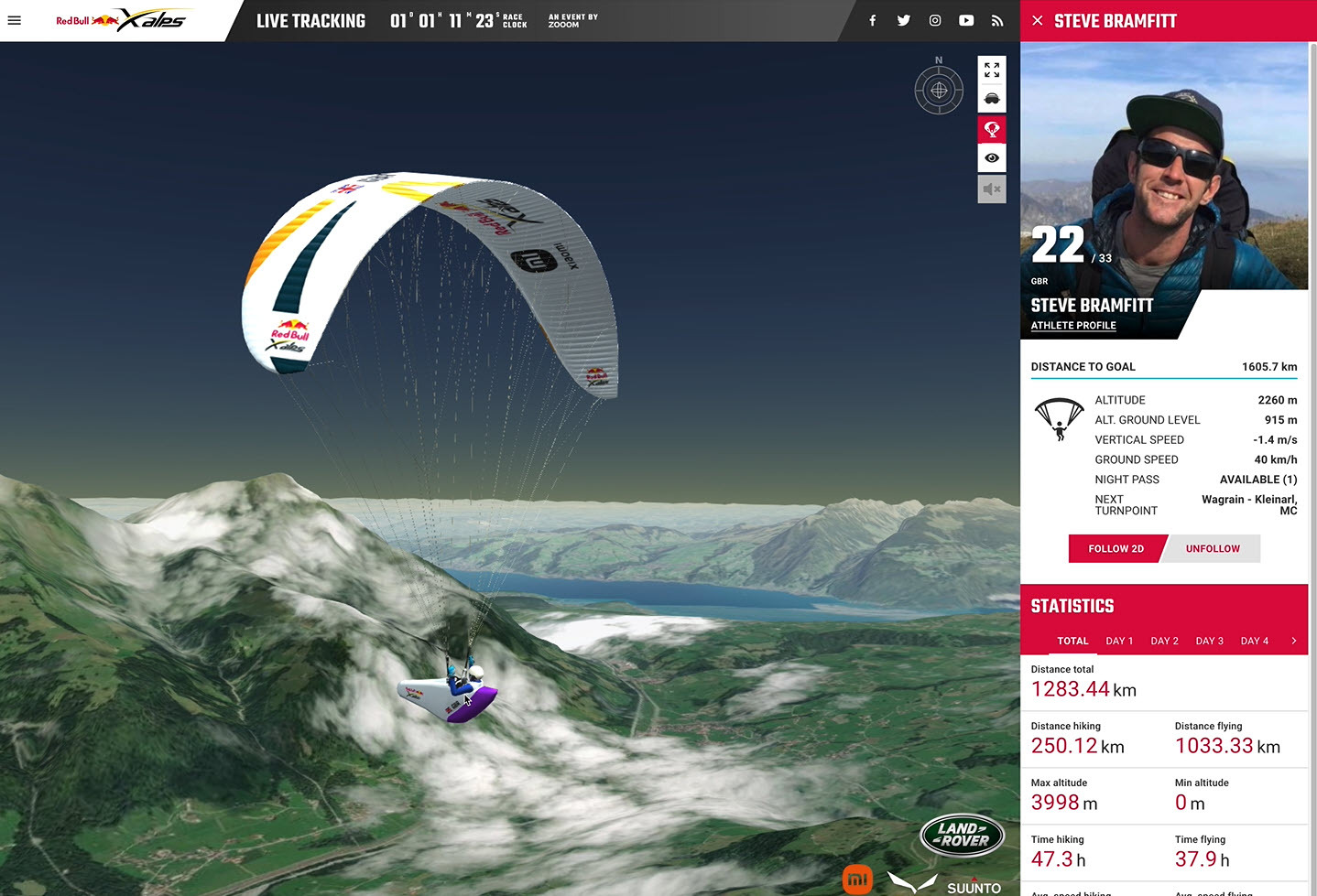
Zooom’s Live Tracking app will allow hundreds of millions of fans to follow 30 competitors from 15 nations in real time using advanced GPS trackers. Esri’s topography data layers provide the high-quality imagery, mapping, and a geographic perspective needed to create a truly immersive experience for viewers of the competition.
The Live Tracking interface tells spectators everything they need to know about an athlete, including speed, altitude, covered distance, even enabling them to jump into the pilot’s seat with a virtual view. The 3D virtual reality imagery is made possible by the basemaps easily integrated using ArcGIS Platform.
The main race of the Red Bull X-Alps 2021 will start June 20 in historic Salzburg, Austria, with the route extending all the way to Mont Blanc on the French and Italian border, and concludes July 2 in Zell am See, Austria.
To learn more about Esri's ArcGIS Platform, visit go.esri.com/Platform-Learn-More.
About Esri
Esri, the global market leader in geographic information system (GIS) software, location intelligence, and mapping, helps customers unlock the full potential of data to improve operational and business results. Founded in 1969 in Redlands, California, USA, Esri software is deployed in more than 350,000 organizations globally and in over 200,000 institutions in the Americas, Asia and the Pacific, Europe, Africa, and the Middle East, including Fortune 500 companies, government agencies, nonprofits, and universities. Esri has regional offices, international distributors, and partners providing local support in over 100 countries on six continents. With its pioneering commitment to geospatial information technology, Esri engineers the most innovative solutions for digital transformation, the Internet of Things (IoT), and advanced analytics. Visit us at esri.com.
Copyright © 2021 Esri. All rights reserved. Esri, the Esri globe logo, ArcGIS, The Science of Where, esri.com, and @esri.com are trademarks, service marks, or registered marks of Esri in the United States, the European Community, or certain other jurisdictions. Other companies and products or services mentioned herein may be trademarks, service marks, or registered marks of their respective mark owners.
Contacts
Jo Ann Pruchniewski
Public Relations, Esri
Mobile: 301-693-2643
Email: jpruchniewski@esri.com