Maxar Partners With Array Labs to Fuel Its 3D Operational Terrain
Maxar Partners With Array Labs to Fuel Its 3D Operational Terrain
Array Labs’ upcoming constellation will fuel rapid updates to Maxar’s global 3D terrain, providing unparalleled insights for warfighters, analysts and commercial operators
WESTMINSTER, Colo. & PALO ALTO, Calif.--(BUSINESS WIRE)--Maxar Intelligence, the leading provider of secure, precise geospatial insights, and Array Labs today announced an agreement to provide Maxar with dedicated capacity from Array Labs’ 3D radar imaging constellation, which is set to launch in late 2026.
This partnership will combine very high-resolution 3D terrain generated from electro-optical imagery with 3D terrain generated from radar imagery to expand Maxar’s ability to rapidly update its global 3D global data in real-time. Under the agreement, the two companies will extend the current technical validation activities and work closely to integrate Array Labs data into the Maxar 3D product line.
Rapidly updated 3D global terrain data provides defense, intelligence and commercial customers with unparalleled insights into their true operating environment and enable opportunities to further enhance the capabilities of next-gen tactical mission-focused products like Raptor, which provides GPS resilience for autonomous drone systems.
“Our partnership with Array Labs will help us achieve our vision of building a living globe—a highly accurate, real-time 3D representation of Earth—that can help solve critical challenges across warfighting, intelligence and commercial domains,” said Peter Wilczynski, Chief Product Officer at Maxar Intelligence. “This additional capacity from Array Labs will help maintain a simulated 3D terrain that matches the real-world operating environment to give our customers a decisive advantage—from the digital battlefield to the connected city.”
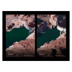
Maxar’s 3D global terrain data already consists of 100 million-plus sq km around the world, delivered with 3-meter SE90 accuracy. This data is regularly updated to provide a reliable view of the operational terrain.
"This is a pivotal moment in transforming how the world accesses, understands, and derives value from 3D data," said Isaac Robledo, cofounder of Array Labs. "By combining our unique space systems and collection capabilities with Maxar's global terrain products, we are expanding the aperture of what's possible with our 3D data – creating more value for defense, intelligence, and commercial end-users and delivering unprecedented insights at the speed of change."
Once Array Labs’ constellation is operational, it will become the latest addition to Maxar’s virtual constellation, which brings together complementary remote sensing capabilities to enable comprehensive, real-time geospatial insights and intelligence.
To learn more about Maxar’s global 3D terrain data, visit https://www.maxar.com/maxar-intelligence/products/theglobein3d.
About Maxar Intelligence
Maxar Intelligence is a leading provider of secure, precise geospatial insights. Operating the most advanced commercial Earth observation constellation on orbit, we use the power of very high-resolution satellite imagery and software technology to deliver mission success on Earth and in space. Our secure, AI-powered products and services deliver ground truth in near real-time to keep nations safe, improve navigation, protect our planet, speed up disaster response and more. For more information, visit www.maxar.com.
About Array Labs
Array Labs is an advanced aerospace company developing the satellites, sensors, and software required to deliver the first real-time, high-fidelity 3D map of Earth. Array’s innovative approach leverages distributed radar, formation flight, multi-static SAR imaging, and advanced image formation algorithms to deliver unprecedented insights into our planet's surface. Headquartered in Palo Alto, California, Array is on track to launch its first 3D imaging cluster in late 2026.
Contacts
Media Contact:
Tomi Maxted
Maxar Intelligence
Tomi.maxted@maxar.com
Ryan Duffy
Array Labs, Inc.
ryan@arraylabs.io