Europe’s Most Advanced Weather Satellite Is Now Fully Operational
Europe’s Most Advanced Weather Satellite Is Now Fully Operational
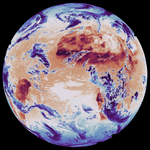
DARMSTADT, Germany--(BUSINESS WIRE)--The first of EUMETSAT’s Meteosat Third Generation (MTG) satellites became fully operational today.
MTG-Imager 1 also receives a new name – Meteosat-12 – to mark the occasion.
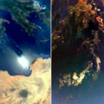
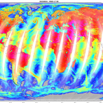
The two main instruments on board Meteosat-12, the Flexible Combined Imager (FCI) and the Lightning Imager (LI), play a crucial role in enabling meteorological services to help protect lives and livelihoods by providing high-resolution, accurate data for predicting severe weather events.
Data from Meteosat-12’s instruments are now being disseminated to national meteorological services and others for operational use and are expected to have a significant impact on weather forecasting and understanding of our climate.
“MTG is one of the most innovative and complex meteorological satellite systems ever built,” EUMETSAT Director-General Phil Evans said.
“We have been working with our member states’ meteorological services to ensure they can make the best use of the data, which is essential for one of the main challenges they face - the rapid detection and forecasting of severe weather so that citizenry, civil authorities and first responders receive timely warnings.”
“When the full constellation of MTG is in place, it will be possible, for the first time, to observe the full lifecycle of a convective storm, from before clouds begin to form through to detection of lightning strikes.”
Efficient and impactful use of this new data will also be central to the EU-funded Space for Early Warnings in Africa project, implemented with the African Union Commission. Today, Council approved EUMETSAT’s involvement via an agreement with the European Commission. Starting in January 2025, the project will enhance African capacity to access and process Earth observation data, strengthening early warning systems and resilience to severe weather.
In addition to the FCI and LI, Meteosat-12 also carries the Data Collection and Retransmission Service (DCS) and the Geostationary Search and Rescue Relay (GEOSAR) transponder.
The DCS acquires observations and environmental data from ground-based meteorological platforms in its field of view then transmits them to the MTG ground segment. The GEOSAR transponder acquires signals from distress beacons in its field of view and transmits them to rescue services.
An anomaly in a module of the Flexible Combined Imager meant its commissioning phase lasted longer than anticipated when the spacecraft was launched in mid-December 2022.
“A great deal of hard work, dedication and ingenuity went in to overcoming the anomaly while the satellite was already in orbit 36,000km above the Earth,” Evans said. “I pay tribute to the EUMETSAT teams, supported by ESA and the industry, that achieved that feat and enabled us to reach this important milestone today where we are confident of the quality and reliability of the data we are providing to those who need it.”
Note to editors:
- live imagery from Meteosat-12 is available on the EUMETSAT website: https://www.eumetsat.int/real-time-imagery/earth-view
- Media kit: UNDER EMBARGO UNTIL 04.12.2024 AT 13h15 - METEOSAT 12 becomes operational | Trello
About EUMETSAT
EUMETSAT, Europe’s meteorological satellite agency, monitors the weather and climate from space. Based in Darmstadt, Germany, EUMETSAT provides its 30 member states with meteorological imagery and data that are essential for keeping their communities safe and for the benefit of critical sectors of their economies.
EUMETSAT’s 30 member states are: Austria, Belgium, Bulgaria, Croatia, Czech Republic, Denmark, Estonia, Finland, France, Germany, Greece, Hungary, Iceland, Ireland, Italy, Latvia, Lithuania, Luxembourg, the Netherlands, Norway, Poland, Portugal, Romania, Slovakia, Slovenia, Spain, Sweden, Switzerland, Türkiye and the United Kingdom.
For more information, see the EUMETSAT website.
Contacts
Media Relations EUMETSAT:
Tel: +49 6151 807 7320
Email: press@eumetsat.int
www.eumetsat.int