Niantic Spatial and Vantor Partner to Deliver Unified Air-to-Ground Positioning in GPS-Denied Areas
Niantic Spatial and Vantor Partner to Deliver Unified Air-to-Ground Positioning in GPS-Denied Areas
Partnership will deliver an integrated visual positioning system, providing GPS redundancy for autonomous and mixed reality operations
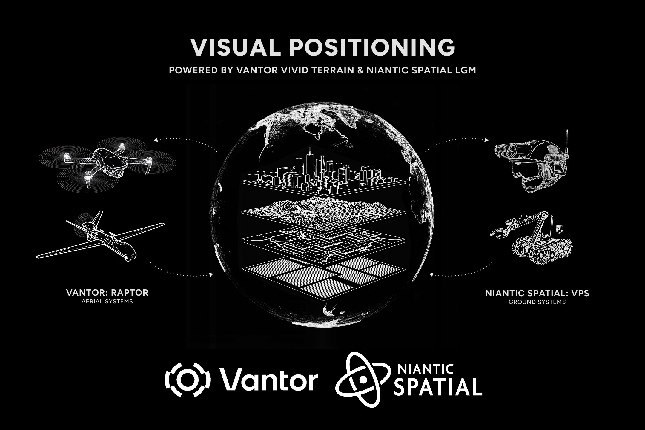
Niantic Spatial and Vantor are building a comprehensive positioning solution that will enable air and ground platforms to navigate and coordinate precisely in GPS-denied environments. The joint capability will leverage Niantic Spatial’s ground-based Visual Positioning System and Vantor’s aerial-focused Raptor visual positioning software to create a shared coordinate system from the live video feeds of autonomous drones, vehicles, AR glasses, and other field assets.
SAN FRANCISCO & WESTMINSTER, Colo.--(BUSINESS WIRE)--Niantic Spatial, the pioneer in geospatial AI, and Vantor, the leading provider of unified spatial intelligence, today announced a partnership to deliver a comprehensive positioning solution that will enable air and ground platforms to navigate and coordinate precisely in GPS-denied environments. Field testing of the integrated system is planned for early 2026.
The partnership addresses a critical vulnerability in modern operations: GPS unavailability, spoofing, interference, and jamming. When satellite signals are compromised, autonomous systems and field teams lose their ability to orient, coordinate or maintain accurate situational awareness.
To address this, Niantic Spatial and Vantor are integrating two distinct, industry-leading localization technologies to create a unified operating picture. The joint capability will leverage Niantic Spatial’s ground-based Visual Positioning System (VPS) and Vantor’s aerial-focused Raptor visual positioning software to create a shared coordinate system from the live video feeds of autonomous drones, vehicles, AR glasses, and other field assets.
A Shared Coordinate System for GPS-Denied Operations
Spatial foundation models form the connective tissue for the elements of the shared coordinate system:
- On the Ground (Niantic Spatial): Niantic Spatial provides localization for ground-based users by visually aligning camera feeds against its model.
- In the Air (Vantor): Vantor provides localization for aerial platforms by visually aligning sensor feeds against its proprietary 3D data.
Combining these two capabilities offers an integrated air-to-ground system capable of allowing any sensor to determine its position in the real world. This ensures that a drone in the sky and a person on the ground can share coordinates in real-time, even without a GPS signal.
“By combining Niantic Spatial’s expertise in ground-based localization with Vantor’s proven aerial systems and global 3D foundation, we’re building an integrated positioning network that operates anywhere,” said Brian McClendon, Chief Technology Officer at Niantic Spatial. “Our Large Geospatial Model gives these systems the ability to perceive, align, and operate in a shared frame of reference — even when traditional GPS is unavailable.”
“The rise of autonomous and mixed reality systems is reshaping our world, but these systems only work if they can maintain precise location intelligence when GPS is down,” said Peter Wilczynski, Vantor’s Chief Product Officer. “Raptor powers GPS-independent autonomy in the air, and we’re partnering with Niantic Spatial to bring this capability to the ground. Together, we can connect any air- or ground-based camera feed to a unified view of the operational terrain for continuous operations. Built on field-tested software, this solution will easily integrate with hardware systems to give operators a decisive advantage in the field.”
About Niantic Spatial
Niantic Spatial is building a living model of the world that people and machines can talk to. Powered by a Large Geospatial Model (LGM) trained on real-world data, our technology delivers high-fidelity 3D reconstruction, centimeter-level localization, and semantic understanding of physical spaces. These capabilities enable AI, robotics, and wearables to perceive, navigate, and understand the world with unprecedented precision and intelligence. To learn more, visit www.nianticspatial.com.
About Vantor
Vantor is forging the new frontier of spatial intelligence to unlock a more autonomous, interoperable world. We give decision makers and operators the power to build a unified intelligence picture, delivering the clarity they need to navigate what’s happening now and shape what’s coming next. We fuse data from the world’s most capable imaging satellites with real-time sensor feeds from space, air, and ground to create an AI-ready digital replica of Earth. Our spatial intelligence platform automates every part of the cycle—from tasking to collection to production—to update and analyze this foundation at the pace of change. Our products drive deeper mission-critical insights and connect the next generation of autonomous systems across the defense, intelligence, and commercial landscape. To learn more, visit www.vantor.com.
Contacts
Media Contacts
Tomi Maxted
Vantor
Tomi.maxted@vantor.com
Tom Glover
Niantic Spatial
tglover@nianticspatial.com