Maxar Awarded $14M+ Contract by the Netherlands Ministry of Defence for Multi-Year Access to Maxar Geospatial Platform Pro
Maxar Awarded $14M+ Contract by the Netherlands Ministry of Defence for Multi-Year Access to Maxar Geospatial Platform Pro
The agreement includes on-demand access to Maxar’s 20-year satellite imagery archive, tasking, 3D data, AI/ML and more
WESTMINSTER, Colo.--(BUSINESS WIRE)--Maxar Intelligence, a provider of secure, precise geospatial insights, today announced it was awarded a €13.6M ($14.4M) framework contract by the Netherlands Ministry of Defence (MoD) for a four-year subscription to Maxar Geospatial Platform (MGP) Pro and associated geospatial products and solutions.
Under the competitive framework agreement, Maxar will help the MoD’s Defence Geographic Agency (DGA) and its hundreds of users enrich the agency’s geospatial foundational data and derivative product portfolio in support of its mapping, intelligence and operational support missions.
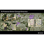
MGP Pro provides on-demand access to the world’s most recent high-accuracy, high-resolution satellite imagery and analytics in a single, powerful platform. In addition to Maxar’s 20-year, 125-petabyte imagery archive, customers receive daily collections—now including WorldView Legion imagery—as well as the ability to task satellites, access 3D data and apply AI and machine learning capabilities for object detection, change monitoring and more.
“At a time of increasing geopolitical instability, Maxar is proud of deepening our partnership with the Netherlands Ministry of Defence through mission critical geospatial intelligence capabilities,” said Anders Linder, General Manager, International Government at Maxar. “Governments trust the capabilities and security of Maxar’s platform to enhance their foundational geospatial data layers and provide timely, mission-critical insights that support requirements across all domains.”
With MGP Pro, Netherlands MoD users can access 3 million sq km of daily 30 cm-class resolution image collections, plus more than 6 billion sq km of archived imagery at up to 30 cm resolution.
About Maxar Intelligence
Maxar Intelligence is a leading provider of secure, precise geospatial insights. Operating the most advanced commercial Earth observation constellation on orbit, we use the power of very high-resolution satellite imagery and software technology to deliver mission success on Earth and in space. Our secure, AI-powered products and services deliver ground truth in near real-time to keep nations safe, improve navigation, protect our planet, speed up disaster response and more. For more information, visit www.maxar.com.
Contacts
Media contact
Sarra Mander
Maxar Intelligence communications lead for International Government
Sarra.mander@maxar.com