Maxar Previews Its New Maxar® Geospatial Platform at Esri UC
Maxar Previews Its New Maxar® Geospatial Platform at Esri UC
WESTMINSTER, Colo.--(BUSINESS WIRE)--Maxar Technologies, provider of comprehensive space solutions and secure, precise, geospatial intelligence, today announced the initial release of its new Maxar Geospatial Platform (MGP), enabling fast and easy access to the world’s most advanced Earth intelligence. MGP will simplify the discovery, purchasing and integration of geospatial data and analytics.
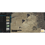
MGP users will have access to Maxar’s industry-leading geospatial content, including high-resolution satellite imagery, stunning imagery basemaps, 3D models, analysis-ready data, and image-based change detection and analytic outputs.
Three tailor-made applications on MGP are designed to meet customer requirements:
- MGP Xpress: Browse, discover and buy high-resolution satellite imagery from Maxar’s 125+ petabyte imagery library.
- MGP Pro: Subscribe to secure, on-demand access to Maxar’s imagery library, daily collections, imagery basemaps and other geospatial data products.
- MGP APIs: Integrate application program interfaces (APIs), software development kits (SDK), and plugins to simplify analytic tasks or power customer apps with Maxar content. For example, a customer can browse our catalog of the highest-quality geospatial data, order any available content, or start analytical workflows in a matter of minutes.
“Maxar has been collecting the highest quality Earth Intelligence for more than 20 years, and MGP revolutionizes how customers and the general public can access that premium content to improve their decision-making processes,” said Dan Jablonsky, Maxar President and Chief Executive Officer. “MGP will enable experienced analysts, technical developers and occasional users of geospatial data to equally leverage Maxar data for mapping, monitoring and analysis in their workflows.”
Select customers can access MGP now. Maxar expects MGP will be ready for broad adoption later this year. Esri User Conference attendees can schedule a demo to experience MGP at Maxar’s booth between July 11-13, 2023, in San Diego, California.
About Maxar
Maxar Technologies is a provider of comprehensive space solutions and secure, precise, geospatial intelligence. We deliver disruptive value to government and commercial customers to help them monitor, understand and navigate our changing planet; deliver global broadband communications; and explore and advance the use of space. Our unique approach combines decades of deep mission understanding and a proven commercial and defense foundation to deploy solutions and deliver insights with unrivaled speed, scale and cost effectiveness. Maxar’s 4,600 team members in over 20 global locations are inspired to harness the potential of space to help our customers create a better world. For more information, visit www.maxar.com.
Contacts
Kristin Carringer
Maxar Media Relations
1-303-684-4352
kristin.carringer@maxar.com