New Topcon Robotic Total Station System Built for Versatile Survey and Construction Workflow Performance
New Topcon Robotic Total Station System Built for Versatile Survey and Construction Workflow Performance

LIVERMORE, Calif.--(BUSINESS WIRE)--Topcon Positioning Group announces new flagship GT Series robotic total stations are available for survey, construction, and machine control applications. The GT-1200 and GT-600 total stations are available in multiple accuracy levels.
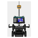
The new total stations are part of a full workflow solution, including a new field computer, a full-version update to Topcon field and office software, as well as GNSS receivers. The system is designed to work in sync for improved performance and better data handling with built-in, field-to-office connectivity.
The speed, tracking and accuracy of the GT Series, combined with the intuitive software system, creates a flexible solution capable of satisfying the technology needs of surveyors and contractors performing survey, layout or machine guidance projects.
“The new total stations perform at a faster 10 Hz positioning update rate. Combining the GT Series with the new field computer and software enhancements, this tracking improvement makes layout easier, and guidance more fluid, within an intuitive map view. More layout and survey points can be collected in less time,” said Ray Kerwin, director of global product planning.
“Surveyors, contractors, as well as heavy machinery automation operators and other construction professionals can benefit from the time-savings and accuracy the series provides,” said Kerwin.
Advanced UltraTrac prism tracking combines optical sensing with a new ultrasonic motor control algorithm designed to maintain superior prism-lock.
“Tracking fast moving targets and maintaining prism-lock is now easier on challenging job sites as well as in machine guidance applications. If you’re performing a machine control project where the prism is vibrating on the end of the blade, for instance, the GT will lock onto the prism better than ever before and provide smoother machine guidance,” Kerwin said.
From a software perspective, MAGNET improves field-based quality reporting and data handling for larger files, graphical processing, and 3D models. MAGNET Field features more visual- and map-based workflows in addition to menu-driven functionality popular with power users.
An optional upgrade incorporating Hybrid Positioning technology helps advanced users get instant location updates via GNSS receivers so positioning data points can be captured, even with the loss of line of sight from job site obstructions.
The complete GT Series workflow solution — MAGNET software, FC-6000 field computer, and HiPer Series GNSS receivers — combine for easy-to-use digital processes designed to help surveyors and contractors increase precision, reduce rework, and improve quality control.
More on the series and solutions is available at topconpositioning.com.
About Topcon Positioning Group
Topcon Positioning Group, always one step ahead in technology and customer benefits, is an industry leading designer, manufacturer and distributor of precision measurement and workflow solutions for the global construction, geospatial and agriculture markets. Topcon Positioning Group is headquartered in Livermore, California, U.S. (topconpositioning.com, LinkedIn, Twitter, Facebook). Its European head office is in Capelle a/d IJssel, the Netherlands. Topcon Corporation (topcon.com), founded in 1932, is traded on the Tokyo Stock Exchange (7732).
Contacts
Topcon Positioning Group
corpcomm@topcon.com
Staci Fitzgerald, +1 925-245-8610