Arizona Metals Corp announces that Kay Mine drilling up-dip of the Hinge Zone intersects 39.9 m of 3.4% CuEq (incl. 3.5 m of 11.6% CuEq and 3.5 m of 6.6% CuEq) and down-dip hits 38.4 m of 2.9% CuEq, (incl. 12.5 m of 6.0 % CuEq)
Arizona Metals Corp announces that Kay Mine drilling up-dip of the Hinge Zone intersects 39.9 m of 3.4% CuEq (incl. 3.5 m of 11.6% CuEq and 3.5 m of 6.6% CuEq) and down-dip hits 38.4 m of 2.9% CuEq, (incl. 12.5 m of 6.0 % CuEq)
And Outlines Upcoming 11,000 m Phase 2 Drill Program at the Kay Mine
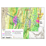
TORONTO--(BUSINESS WIRE)--Arizona Metals Corp. (TSX.V:AMC) (the “Company” or “Arizona Metals”) is pleased to announce that all four recently completed holes at its Kay Mine project in Yavapai County, Arizona, intersected massive sulphide mineralization, both up-dip and down-dip of the hinge zone intersection announced in August 2020, in which hole KM-20-13 intersected a broad interval of 43.1 m at a grade of 3.9% CuEq, including 15.2 m grading 6.7% CuEq.
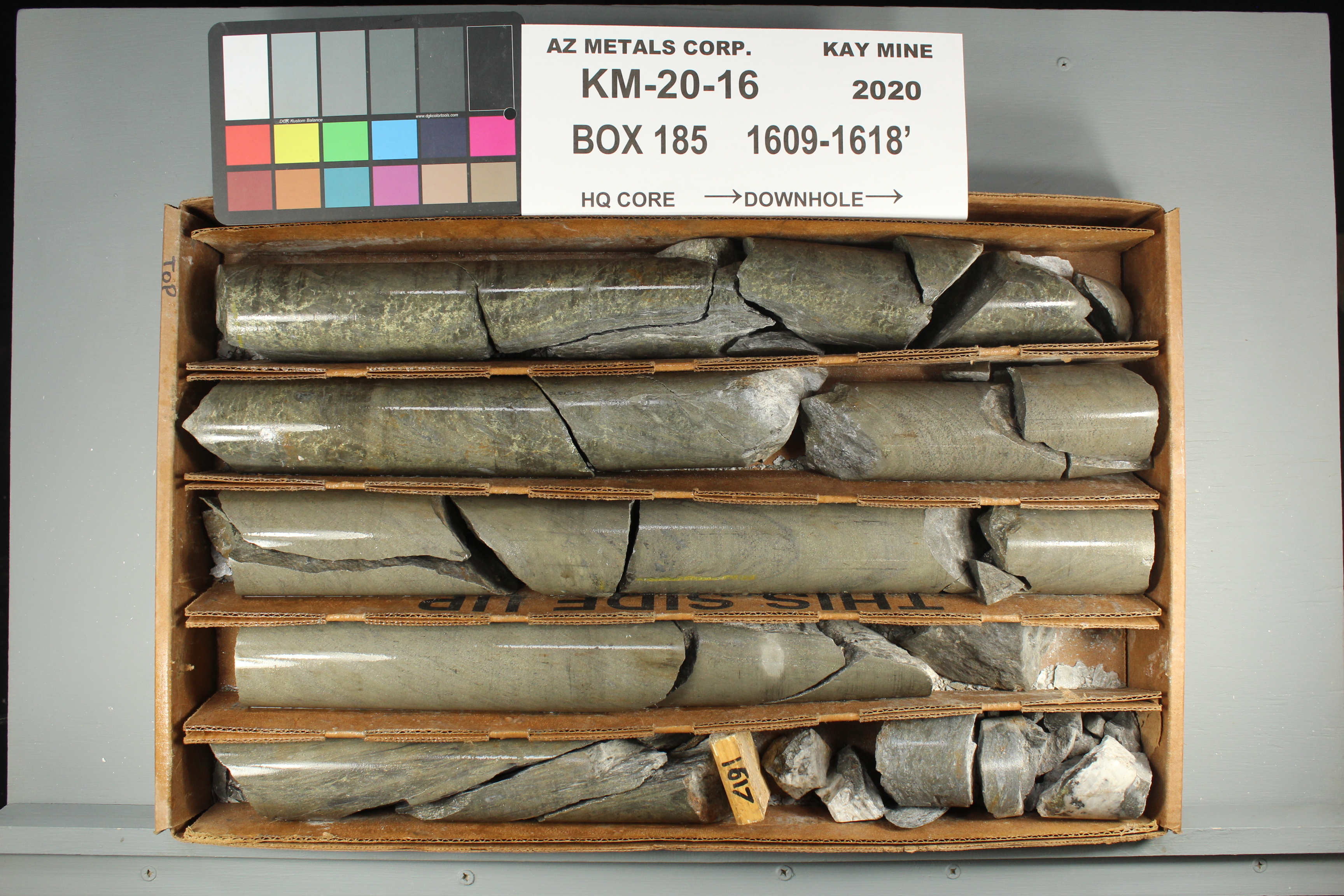
Hole KM-20-16 was drilled 50 m down-dip of hole KM-20-13, and intersected 38.4 m grading 2.9% CuEq, including 12.5 m at a grade of 6.0% CuEq, as well as 3.5 m of 10.2% CuEq and 3.0 m of 11.3% CuEq, from a depth of 385 m vertically below surface (Figure 1).
Hole KM-20-14 was drilled 50 m up-dip of hole KM-20-13 and intersected an interval of 39.9 m at a grade of 3.4% CuEq, including 3.5 m grading 11.6% CuEq, as well as 3.5 m of 6.6% CuEq.
Branch hole KM-20-14A was drilled 40 m up-dip of hole KM-20-13, and 50 m north of trunk hole KM-20-14. This hole intersected 22.5 m at a grade of 2.4% CuEq, including 4.1 m of 5.2% CuEq and 0.8 m of 14.0% CuEq.
Hole KM-20-15 was drilled 50 m up-dip of hole KM-20-10C (which intersected 6.8 m of 7.3 g/t AuEq) in a previously announced potential new gold-zinc rich lens. This hole intersected 3.3m of 11.3% ZnEq.
Marc Pais, CEO, commented “Holes KM-20-14 and KM-20-14A have successfully intersected massive sulphide mineralization 50 m up-dip of the broad high-grade hinge zone identified in hole KM-20-13. These two holes also demonstrate the potential to identify wide intervals of high-grade mineralization in the hinge zone over at least 50 m of strike extent.
Hole KM-20-16 successfully intersected massive sulphide mineralization 50 m down-dip of the high-grade hinge zone identified in Hole KM-20-13.
Hole KM-20-15 is located in an area of newly-defined gold-rich zinc mineralization, and was drilled 30 m south of KM-20-10C (6.8m of 7.3g/t AuEq) in order to test the strike extension of the potential gold-rich zinc lens. This hole intersected 3.3m of 11.3% ZnEq, located 50 m up-dip of the previously identified gold-rich zinc mineralization, and also by 30 m into a previously untested area to the south.
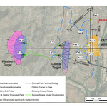
Last month we completed a downhole electromagnetic testing program, in order to better define new targets for extension of the hinges. These geophysical results were used in conjunction with today’s results to plan the Phase 2 drill program detailed below (Figure 4).
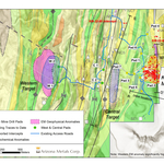
We believe there is excellent potential to expand the Kay Mine deposit, which currently covers a strike length of only 320 m, on strike both to the north and south. Permitting is currently underway for two drill pads to test 500 m of strike to the north, and another pad to test 300 m of strike to the south. We are also permitting drill pads for the Central Target, located 500 m west of Kay, and the Western Target, located 1,000 m west of Kay. Arizona Metals has completed structural mapping, soil sampling, rock sampling, and a helicopter VTEM survey over these targets, all of which show coincident anomalies (Figure 5). We are excited to start drilling these targets later this year, as we believe both have the potential to host one or more deposits similar to the Kay Mine.”
Kay Mine Phase 2 Drill Program to Commence Q4 2020
Permitting is currently underway to test the Kay Mine deposit on strike by 500m to the north as well as 300m to the south. The Company is also planning to test the previously undrilled Central and Western Targets later this year. The total Phase 2 drill program would consist of up to 11,000m in 29 core drill holes (Figure 4). Arizona Metals has completed structural mapping, soil sampling, rock sampling, and a helicopter VTEM survey over these targets, all of which show coincident anomalies (Figure 5).
Table 1. Locations of Phase 1 Program drill holes completed and in progress at Kay Mine, Arizona
| Hole ID | Drill Pad | Zone | Collar East WGS84 |
Collar North WGS84 |
Collar Elev m |
Collar Az |
Collar Dip |
| KM-20-01 | Pad 1 | North | 392684 |
3769388 |
643 |
78 |
-48 |
| KM-20-02 | Pad 1 | North | 392684 |
3769388 |
643 |
75 |
-50 |
| KM-20-03 | Pad 1 | North | 392684 |
3769388 |
643 |
72 |
-43.3 |
| KM-20-03A | Pad 1 | North | 392684 |
3769388 |
643 |
72 |
-43.3 |
| KM-20-04 | Pad 1 | North | 392684 |
3769388 |
643 |
65.1 |
-47.5 |
| KM-20-05 | Pad 1 | North | 392684 |
3769388 |
643 |
73.3 |
-47.2 |
| KM-20-06 | Pad 1 | North | 392684 |
3769388 |
643 |
81.3 |
-48.3 |
| KM-20-07 | Pad 1 | North | 392684 |
3769388 |
643 |
85.6 |
-47.6 |
| KM-20-08 | Pad 2 | South | 392638 |
3769266 |
653 |
91.1 |
-77.1 |
| KM-20-09 | Pad 2 | South | 392638 |
3769266 |
653 |
92.1 |
-77 |
| KM-20-10 | Pad 2 | South | 392638 |
3769266 |
653 |
96.3 |
-72.2 |
| KM-20-10A | Pad 2 | South | 392638 |
3769266 |
653 |
96.3 |
-72.2 |
| KM-20-10B | Pad 2 | South | 392638 |
3769266 |
653 |
96.3 |
-72.2 |
| KM-20-10C | Pad 2 | South | 392638 |
3769266 |
653 |
96.3 |
-72.2 |
| KM-20-11 | Pad 3 | North | 392552 |
3769328 |
638 |
57.3 |
-67.5 |
| KM-20-12 | Pad 1 | North | 392684 |
3769388 |
643 |
95.7 |
-70.8 |
| KM-20-13 | Pad 1 | South | 392684 |
3769388 |
643 |
124 |
-66.5 |
| KM-20-14 | Pad 1 | South | 392684 |
3769388 |
643 |
133.6 |
-66 |
| KM-20-14A | Pad 1 | South | 392684 |
3769388 |
643 |
133.6 |
-66 |
| KM-20-15 | Pad 2 | South | 392638 |
3769266 |
653 |
106.7 |
-66.8 |
| KM-20-16 | Pad 2 | South | 392638 |
3769266 |
653 |
91.5 |
-68.9 |
Covid-19 Monitoring and Mitigation Procedures
The Company’s drill contractor, Boart Longyear, has instituted Covid-19 monitoring procedures for all drill crew members, including daily temperature and symptom checks. Arizona Metals will be provided with daily health tracking updates for the drill crews and has also instituted its own social distancing policies and provided a guidance manual for employees at site.
Summary of North Zone Drill Results:
Holes KM-20-01 through KM-20-06 all intersected massive sulphide mineralization. Hole KM-20-07 did not intersect significant mineralization and is believed to have passed between the North and South Zones. Arizona Metals’ drilling tested a vertical extent of approximately 50 m in the North Zone, to a vertical depth between 120-170 m. Historic underground exploration by Exxon Minerals reported mineralization at depths in the North Zone of up to 300 m below recent drilling by Arizona Metals.
Highlights of the first eight holes in the North Zone include:
KM-20-03: 2.7 m grading 5.4% CuEq (incl. 0.9 m of 10.3% CuEq), from a depth of 120 m
KM-20-03A: 4.6 m grading 6.9% CuEq (incl. 0.8 m of 18.2% CuEq) from a depth of 122 m
KM-20-05: 2.4 m grading 9.2% CuEq (incl. 1.2 m of 13.9% CuEq) from a depth of 150 m
KM-20-06: 13.5 m grading 2.9% CuEq (incl. 4.9 m of 4.5% CuEq) from a depth of 158 m
KM-20-11: 2.7 m grading 9.2% CuEq from a depth of 490 m
KM-20-12: 4.9 m grading 4.8% CuEq (incl. 1.9 m of 10.1% CuEq) from a depth of 318 m
KM-20-12: 25.9 m grading 0.9% CuEq, from a depth of 326 m
Table 2. Results of Initial Drill Program at Kay Mine North Zone, Yavapai County, Arizona
Hole ID |
From m |
To m |
Vertical
|
Length
|
CuEq
|
Au g/t |
Ag g/t |
Cu % |
Pb % |
Zn % |
| KM-20-01 | 275.8 |
281.5 |
156 |
5.6 |
1.70 |
0.48 |
11.6 |
0.57 |
0.18 |
1.20 |
| including | 275.8 |
276.5 |
0.6 |
4.23 |
1.22 |
32.0 |
0.50 |
0.73 |
5.04 |
|
| including | 279.8 |
281.5 |
1.6 |
3.10 |
0.98 |
22.6 |
1.21 |
0.23 |
1.49 |
|
| KM-20-02 | 297.8 |
300.8 |
172 |
3.0 |
1.01 |
0.20 |
1.4 |
0.77 |
0.01 |
0.04 |
| KM-20-03 | 256.3 |
259.1 |
120 |
2.7 |
5.41 |
1.01 |
69.6 |
3.40 |
0.09 |
0.65 |
| including | 256.3 |
257.3 |
0.9 |
10.32 |
1.79 |
56.0 |
7.42 |
0.17 |
1.11 |
|
| KM-20-03 | 292.2 |
292.6 |
152 |
0.5 |
2.72 |
0.19 |
2.0 |
2.43 |
0.04 |
0.15 |
| KM-20-03 | 295.8 |
296.3 |
154 |
0.5 |
2.61 |
0.80 |
6.0 |
1.35 |
0.06 |
0.91 |
| KM-20-03A | 252.4 |
256.9 |
122 |
4.6 |
6.85 |
2.55 |
35.6 |
3.70 |
0.03 |
0.27 |
| including | 252.4 |
253.1 |
0.8 |
18.19 |
6.34 |
164.0 |
9.74 |
0.11 |
0.40 |
|
| KM-20-05 | 266.6 |
269.0 |
150 |
2.4 |
9.19 |
1.94 |
43.3 |
6.47 |
0.14 |
0.57 |
| including | 266.6 |
267.8 |
1.2 |
13.89 |
2.21 |
50.0 |
10.60 |
0.26 |
1.05 |
|
| KM-20-06 | 267.9 |
281.5 |
158 |
13.5 |
2.92 |
0.85 |
45.6 |
1.02 |
0.30 |
1.23 |
| including | 267.9 |
268.4 |
0.5 |
6.73 |
2.20 |
31.0 |
1.54 |
0.81 |
6.10 |
|
| including | 276.6 |
281.5 |
4.9 |
4.54 |
0.87 |
92.1 |
1.86 |
0.42 |
1.96 |
|
| including | 280.0 |
281.0 |
1.1 |
7.82 |
1.03 |
340.0 |
3.22 |
0.04 |
0.64 |
|
| KM-20-11 | 554.1 |
556.9 |
490 |
2.7 |
9.23 |
2.83 |
70.0 |
4.14 |
0.28 |
3.56 |
| KM-20-12 | 371.9 |
376.7 |
318 |
4.9 |
4.76 |
0.37 |
12.4 |
3.99 |
0.07 |
0.62 |
| including | 371.9 |
373.7 |
1.9 |
10.10 |
0.67 |
28.0 |
8.49 |
0.16 |
1.53 |
|
| KM-20-12 | 379.5 |
405.4 |
326 |
25.9 |
0.87 |
0.08 |
2.3 |
0.73 |
0.01 |
0.08 |
(1) True widths of the reported mineral intervals have not been determined; additional drilling is required. |
(2) Assumptions used in USD for the copper equivalent calculation were metal prices of $2.28/lb Copper, $1650/oz Gold, $15/oz Silver, $0.86/lb Zinc, $0.77/lb Pb and recovery is assumed to be 100% as no metallurgical test data is available. The following equation was used to calculate copper equivalence: CuEq = Copper (%) + (Gold (g/t) x 1.06) + (Silver (g/t) x 0.0096) + (Zinc (%) x 0.3772) +(Lead (%) x 0.3377). |
Summary of South Zone Drill Results:
Below are highlights of drilling to date in the South Zone:
KM-20-09: 6.1 m grading 7.8 g/t AuEq, including 4.4 m grading 9.3 g/t AuEq, and also including 1.1 m grading 16.0 g/t AuEq, from a depth of 575 m
KM-20-10A: 10.7 m grading 4.4% CuEq, including 1.5 m grading 8.6% CuEq, 3.1 m grading 4.2% CuEq, and 1.4 m grading 12.2% CuEq from a depth of 442 m
KM-20-10B: 27.6 m grading 2.9% CuEq, including 6.6 m at 4.8% CuEq, 4.4 m grading 5.3% CuEq, and 3.5 m grading 6.7% CuEq from a depth of 423 m
KM-20-10C: 6.8 m grading 7.3 g/t AuEq, including 4.3 m grading 10.1 g/t AuEq, and 0.8 m grading 27.6 g/t AuEq from a depth of 422 m
KM-20-13: 43.1 m grading 3.9% CuEq, including 15.2 m grading 6.7% CuEq and 4.4 m grading 10.3% CuEq from a depth 341 m
KM-20-14: 39.9 m grading 3.4% CuEq, including 3.5 m grading 11.6% CuEq and 3.5 m grading 6.6% CuEq, from a depth of 314 m
KM-20-14A: 22.5 m grading 2.4% CuEq, including 0.8m of 14.0% CuEq and 4.1 m of 5.2% CuEq, from a depth of 312 m. This hole also intersected 4.4 m grading 5.1 % CuEq, incl. 1.7m grading 10.4% CuEq, from a depth of 303 m
KM-20-15: 3.3 m grading 11.3% ZnEq, from a depth of 402 m
KM-20-16: 38.4 m grading 2.9% CuEq, including 12.5 m grading 6.0% CuEq
Table 3. Results of Initial Drill Program at Kay Mine South Zone, Yavapai County, Arizona
| Hole ID | From m | To m | Vertical Depth Below Surface m |
Length (m) 1 |
CuEq (%) 2 |
AuEq (g/t) 3 |
ZnEq (%) 4 |
Au g/t | Ag g/t | Cu % | Pb % | Zn % |
| KM-20-09 | 588.1 |
588.4 |
550 |
0.3 |
3.52 |
1.74 |
15.0 |
0.91 |
0.40 |
1.86 |
||
| KM-20-09 | 613.4 |
614.1 |
568 |
0.7 |
3.15 |
1.81 |
10.0 |
0.90 |
0.08 |
1.04 |
||
| KM-20-09 | 614.6 |
614.9 |
569 |
0.3 |
3.41 |
0.36 |
19.0 |
2.64 |
0.10 |
0.98 |
||
| KM-20-09 | 632.8 |
638.9 |
578 |
6.1 |
7.80 |
4.18 |
41.7 |
0.12 |
0.82 |
8.02 |
||
| including | 633.6 |
637.9 |
4.4 |
9.29 |
5.46 |
33.1 |
0.15 |
0.50 |
9.06 |
|||
| including | 636.9 |
637.9 |
1.1 |
16.03 |
9.77 |
68.0 |
0.17 |
0.78 |
14.65 |
|||
| KM-20-10 | 563.6 |
568.5 |
490 |
4.9 |
6.24 |
2.16 |
24.9 |
2.39 |
0.31 |
3.27 |
||
| including | 563.6 |
566.6 |
3.0 |
7.78 |
2.42 |
28.2 |
3.66 |
0.32 |
3.16 |
|||
| including | 567.2 |
568.5 |
1.2 |
5.33 |
2.52 |
28.4 |
0.33 |
0.43 |
5.10 |
|||
| KM-20-10 | 574.2 |
574.9 |
498 |
0.6 |
10.09 |
4.33 |
113.0 |
0.12 |
0.16 |
11.30 |
||
| KM-20-10 | 577.7 |
579.3 |
500 |
1.6 |
3.09 |
0.70 |
45.9 |
0.03 |
0.68 |
4.38 |
||
| KM-20-10 | 582.3 |
583.1 |
502 |
0.8 |
2.42 |
0.42 |
51.0 |
0.03 |
1.07 |
2.90 |
||
| KM-20-10A | 521.2 |
522.5 |
437 |
1.3 |
7.07 |
1.27 |
51.1 |
2.13 |
0.91 |
7.46 |
||
| KM-20-10A | 527.9 |
538.6 |
442 |
10.7 |
4.40 |
1.66 |
27.2 |
1.32 |
0.30 |
2.58 |
||
| including | 527.9 |
529.4 |
1.5 |
8.59 |
0.92 |
30.2 |
6.69 |
0.07 |
1.62 |
|||
| including | 532.2 |
535.3 |
3.1 |
4.17 |
1.75 |
34.3 |
0.72 |
0.42 |
2.99 |
|||
| including | 537.2 |
538.6 |
1.4 |
12.24 |
7.29 |
79.2 |
0.16 |
0.60 |
9.06 |
|||
| KM-20-10B | 503.0 |
530.7 |
423 |
27.6 |
2.87 |
0.97 |
21.3 |
0.87 |
0.32 |
1.76 |
||
| including | 503.0 |
509.6 |
6.6 |
4.79 |
1.55 |
29.8 |
1.78 |
0.37 |
2.55 |
|||
| including | 513.9 |
518.3 |
4.4 |
5.29 |
1.89 |
47.4 |
1.08 |
0.68 |
4.05 |
|||
| including | 527.2 |
530.7 |
3.5 |
6.68 |
2.32 |
52.9 |
1.91 |
0.99 |
3.93 |
|||
| KM-20-10C | 523.9 |
530.7 |
422 |
6.8 |
7.25 |
3.32 |
102.0 |
0.58 |
1.15 |
5.84 |
||
| including | 523.9 |
528.2 |
4.3 |
10.05 |
4.89 |
125.2 |
0.88 |
1.45 |
7.61 |
|||
| including | 525.6 |
526.4 |
0.8 |
27.62 |
16.65 |
214.0 |
0.52 |
2.76 |
21.40 |
|||
| KM-20-13 | 443.6 |
486.8 |
341 |
43.1 |
3.94 |
1.26 |
23.3 |
1.68 |
0.24 |
1.67 |
||
| including | 444.4 |
459.6 |
15.2 |
6.71 |
1.80 |
38.5 |
3.42 |
0.39 |
2.36 |
|||
| including | 444.4 |
447.1 |
2.7 |
10.14 |
3.74 |
55.0 |
1.02 |
1.88 |
10.64 |
|||
| including | 451.4 |
455.8 |
4.4 |
10.34 |
1.18 |
65.3 |
8.41 |
0.02 |
0.16 |
|||
| KM-20-14 | 421.7 |
461.6 |
314 |
39.9 |
3.40 |
1.00 |
18.4 |
1.47 |
0.19 |
1.67 |
||
| including | 426.3 |
429.8 |
3.5 |
11.58 |
1.28 |
30.0 |
9.56 |
0.07 |
0.95 |
|||
| including | 457.2 |
460.7 |
3.5 |
6.61 |
2.58 |
26.3 |
0.36 |
0.38 |
8.33 |
|||
| KM-20-14A | 404.6 |
409.0 |
303 |
4.4 |
5.07 |
1.48 |
79.2 |
1.67 |
0.41 |
2.50 |
||
| including | 404.6 |
406.4 |
1.7 |
10.41 |
2.46 |
173.6 |
4.08 |
0.53 |
5.02 |
|||
| KM-20-14A | 421.0 |
443.5 |
312 |
22.5 |
2.41 |
0.72 |
15.9 |
0.86 |
0.18 |
1.51 |
||
| including | 421.0 |
421.8 |
0.8 |
14.01 |
2.91 |
45.0 |
9.81 |
0.19 |
1.69 |
|||
| including | 421.0 |
425.0 |
4.1 |
5.17 |
1.14 |
21.4 |
3.23 |
0.14 |
1.30 |
|||
| KM-20-15 | 506.8 |
510.1 |
402 |
3.3 |
11.25% |
0.33 |
192.03 |
0.05 |
1.75 |
3.73 |
||
| KM-20-16 | 480.4 |
518.8 |
385 |
38.4 |
2.87 |
0.81 |
24.3 |
0.85 |
0.25 |
2.24 |
||
| including | 480.4 |
492.9 |
12.5 |
5.95 |
1.98 |
49 |
1.63 |
0.50 |
4.23 |
|||
| including | 480.4 |
483.4 |
3.0 |
11.29 |
4.74 |
77.9 |
2.40 |
0.91 |
7.49 |
|||
| including | 489.8 |
492.9 |
3.0 |
10.22 |
2.59 |
100.7 |
3.61 |
0.92 |
6.90 |
(1) True widths of the reported mineral intervals have not been determined; additional drilling is required |
(2) Assumptions used in USD for the copper equivalent calculations were metal prices of $2.28/lb Copper, $1650/oz Gold, $16/oz Silver, $0.86/lb Zinc, $0.77/lb Pb and recovery is assumed to be 100% as no metallurgical test data is available. The following equation was used to calculate copper equivalence : CuEq = Copper (%) + (Gold (g/t) x 1.06) + (Silver (g/t) x 0.0096) + (Zinc (%) x 0.3772) +(Lead (%) x 0.3377). |
(3) Assumptions used in USD for the gold equivalent calculations were metal prices of $2.28/lb Copper, $1650/oz Gold, $15/oz Silver, $0.86/lb Zinc, $0.77/lb Pb and recovery is assumed to be 100% as no metallurgical test data is available. The following equation was used to calculate gold equivalence: AuEq = Gold (g/t) + (Copper (%) x 94.72) + (Silver (g/t) x 0.009) + (Zinc (%) x 35.73) +(Lead (%) x 31.99). |
(4) Assumptions used in USD for the gold equivalent calculations were metal prices of $2.28/lb Copper, $1650/oz Gold, $15/oz Silver, $0.86/lb Zinc, $0.77/lb Pb and recovery is assumed to be 100% as no metallurgical test data is available. The following equation was used to calculate Zn equivalence: ZnEq = Zinc (%) + (Copper (%) x 2.65) + (Silver (g/t) x 0.0003) + (Lead (%) x 1.12). |
Sugarloaf Peak Project Update
On July 6th, 2020, Arizona Metals commenced a Phase 1 drill program at its Sugarloaf Peak Project in La Paz County, Arizona. Drill core from this program will be sent to Kappes Cassiday and Associates of Reno, Nevada, to undergo bottle-roll and column testing of gold recoveries by leaching of oxide material. Samples will also be sent to ALS Minerals in Reno, Nevada for gold assay, multi-element testing, and spectral analysis to determine trace-element levels and hydrothermal alteration variations.
The Phase 1 program, comprised of four drill holes, has been completed. The program was originally planned to total 1,300 m but was increased to 1,700 m. Two cored drill holes were extended to depths of approximately 550 m each to test a large geophysical target that the Company believes has the potential to host a higher grade “feeder” zone, that could be the source of the disseminated oxide mineralization identified by previous operators. The holes are currently at the lab with assays pending.
Engagement of Equity Guru Media Inc.
Arizona Metals is also pleased to announce that it has engaged Equity Guru Media Inc. (the “Contractor”) to provide media relations services pursuant to a contracting services agreement (the “Services Agreement”). The Services Agreement is dated effective September 22, 2020 and will be effective for a six-month term. Services provided by the Contractor will relate to ongoing communications and promotional support for the Company’s relations with the professional investment community. Pursuant to the Services Agreement, the Company will pay to the Contractor a fee of $30,000 (plus applicable taxes) for a six-month term. The Contractor is an arm's length party to the Company and, to the Company’s knowledge does not currently own any securities of the Company as at the date hereof but may purchase securities in the Company from time to time for investment purposes. The Services Agreement is subject to acceptance by the TSX Venture Exchange.
About Arizona Metals Corp.
Arizona Metals Corp. owns 100% of the Kay Mine Property in Yavapai County, which is located on a combination of patented and BLM claims totaling 1,300 acres that are not subject to any royalties. An historic estimate by Exxon Minerals in 1982 reported a “proven and probable reserve of 6.4 million short tons at a grade of 2.2% copper, 2.8 g/t gold, 3.03% zinc, and 55 g/t silver.” The historic estimate at the Kay Mine was reported by Exxon Minerals in 1982. The historic estimate has not been verified as a current mineral resource. None of the key assumptions, parameters, and methods used to prepare the historic estimate were reported, and no resource categories were used. Significant data compilation, re-drilling and data verification may be required by a Qualified Person before the historic estimate can be verified and upgraded to be a current mineral resource. A Qualified Person has not done sufficient work to classify it as a current mineral resource, and Arizona Metals is not treating the historic estimate as a current mineral resource.
The Kay Mine is a steeply dipping VMS deposit that has been defined from a depth of 60 m to at least 900 m. It is open for expansion on strike and at depth.
The Company also owns 100% of the Sugarloaf Peak Property, in La Paz County, which is located on 4,400 acres of BLM claims. Sugarloaf is a heap-leach, open-pit target and has a historic estimate of “100 million tons containing 1.5 million ounces gold” at a grade of 0.5 g/t (Dausinger, 1983, Westworld Resources).
1The historic estimate at the Sugarloaf Peak Property was reported by Westworld Resources in 1983. The historic estimate has not been verified as a current mineral resource. None of the key assumptions, parameters, and methods used to prepare the historic estimate were reported, and no resource categories were used. Significant data compilation, re-drilling and data verification may be required by a Qualified Person before the historic estimate can be verified and upgraded to a current mineral resource. A Qualified Person has not done sufficient work to classify it as a current mineral resource, and Arizona Metals is not treating the historic estimate as a current mineral resource.
The Qualified Person who reviewed and approved the technical disclosure in this release is David Smith, CPG.
Quality Assurance/Quality Control
All of Arizona Metals’ drill sample assay results have been independently monitored through a quality assurance/quality control (“QA/QC”) protocol which includes the insertion of blind standard reference materials and blanks at regular intervals. Logging and sampling were completed at Arizona Metals’ core handling facilities located in Anthem and Black Canyon City, Arizona. Drill core was diamond sawn on site and half drill-core samples were securely transported to ALS Laboratories’ (“ALS”) sample preparation facility in Tucson, Arizona. Sample pulps were sent to ALS’s labs in Vancouver, Canada, for analysis.
Gold content was determined by fire assay of a 30-gram charge with ICP finish (ALS method Au-AA23). Silver and 32 other elements were analyzed by ICP methods with four-acid digestion (ALS method ME-ICP61a). Over-limit samples for Au, Ag, Cu, and Zn were determined by ore-grade analyses Au-GRA21, Ag-OG62, Cu-OG62, and Zn-OG62, respectively.
ALS Laboratories is independent of Arizona Metals Corp. and its Vancouver facility is ISO 17025 accredited. ALS also performed its own internal QA/QC procedures to assure the accuracy and integrity of results. Parameters for ALS’ internal and Arizona Metals’ external blind quality control samples were acceptable for the samples analyzed. Arizona Metals is not aware of any drilling, sampling, recovery, or other factors that could materially affect the accuracy or reliability of the data referred to herein.
This press release contains statements that constitute “forward-looking information” (collectively, “forward-looking statements”) within the meaning of the applicable Canadian securities legislation, All statements, other than statements of historical fact, are forward-looking statements and are based on expectations, estimates and projections as at the date of this news release. Any statement that discusses predictions, expectations, beliefs, plans, projections, objectives, assumptions, future events or performance (often but not always using phrases such as “expects”, or “does not expect”, “is expected”, “anticipates” or “does not anticipate”, “plans”, “budget”, “scheduled”, “forecasts”, “estimates”, “believes” or “intends” or variations of such words and phrases or stating that certain actions, events or results “may” or “could”, “would”, “might” or “will” be taken to occur or be achieved) are not statements of historical fact and may be forward-looking statements. Forward-looking statements contained in this press release include, without limitation, statements regarding the resumption of drilling and the effects of the COVID-19 pandemic on the business and operations of the Company. In making the forward- looking statements contained in this press release, the Company has made certain assumptions. Although the Company believes that the expectations reflected in forward-looking statements are reasonable, it can give no assurance that the expectations of any forward-looking statements will prove to be correct. Known and unknown risks, uncertainties, and other factors which may cause the actual results and future events to differ materially from those expressed or implied by such forward-looking statements. Such factors include, but are not limited to: availability of financing; delay or failure to receive required permits or regulatory approvals; and general business, economic, competitive, political and social uncertainties. Accordingly, readers should not place undue reliance on the forward-looking statements and information contained in this press release. Except as required by law, the Company disclaims any intention and assumes no obligation to update or revise any forward-looking statements to reflect actual results, whether as a result of new information, future events, changes in assumptions, changes in factors affecting such forward- looking statements or otherwise.
NEITHER THE TSX VENTURE EXCHANGE (NOR ITS REGULATORY SERVICE PROVIDER) ACCEPTS RESPONSIBILITY FOR THE ADEQUACY OR ACCURACY OF THIS RELEASE
Not for distribution to US newswire services or for release, publication, distribution or dissemination directly, or indirectly, in whole or in part, in or into the United States
Contacts
Marc Pais
President and CEO
Arizona Metals Corp.
(416) 565-7689
mpais@arizonametalscorp.com
www.arizonametalscorp.com
https://twitter.com/ArizonaCorp