

Newsroom
Sorted by: Latest
-
CORRECTING and REPLACING Athena Security Launches First-of-Its-Kind Secondary Screening WDS™ Using Advanced Imaging Radar Technology
AUSTIN, Texas--(BUSINESS WIRE)--The new secondary WDS helps security teams screen bags, boots and lower legs with real-time imaging workflows....
-
Cemex Announces Pricing of U.S.$1.5 Billion of 5.750% Senior Notes Due 2036
MONTERREY, Mexico--(BUSINESS WIRE)--Cemex, S.A.B. de C.V. (“Cemex”) (NYSE: CX) announced today the pricing of U.S.$1.5 billion of its 5.750% Senior Notes due 2036 (the “Notes”). The Notes will be guaranteed by Cemex’s subsidiary, Cemex Corp. The Notes will bear interest semi-annually at an annual rate of 5.750% and mature on June 5, 2036. The Notes will be issued at a price of 99.572% of face value. The date of issuance of the Notes is scheduled to occur on June 5, 2026, subject to satisfaction...
-
PGIM Announces Net Asset Value Restatement for Three Exchange-Traded Funds (PAB, PSDM, PTRB)
NEWARK, N.J.--(BUSINESS WIRE)--This restatement is the result of an accounting error in calculating each exchange-traded fund’s NAV by a third-party administrator....
-
Partenariat stratégique entre HTEC et Xsolis pour utiliser l'IA afin de lutter contre les inefficacités dans la prise de décision en santé
PALO ALTO, Californie--(BUSINESS WIRE)--HTEC, société mondiale d'ingénierie et de développement de produits numériques axée sur l'IA, a annoncé aujourd'hui un partenariat stratégique avec Xsolis, une entreprise technologique alimentée par l'IA capable de réduire les gaspillages administratifs en facilitant la collaboration entre les prestataires de soins de santé et les organismes payeurs. Dans tous les systèmes de santé, il existe des incohérences et une lenteur du processus, souvent manuel, q...

-
Eine neue Studie von Tacton zeigt, dass nur 7 % der Hersteller eine End-to-End-Vernetzung der Wertschöpfungskette erreicht haben
CHICAGO & STOCKHOLM--(BUSINESS WIRE)--Tacton, ein Weltmarktführer im Bereich CPQ-Lösungen (Configure, Price, Quote) für Hersteller komplexer, hochgradig konfigurierbarer Produkte, hat heute seinen jährlichen Bericht State of Manufacturing veröffentlicht. Dieser zeigt, dass die zunehmende Produktkomplexität trotz kontinuierlicher Investitionen in die digitale Transformation und KI kritische funktionsübergreifende Lücken offenbart. Die Studie basiert auf einer Befragung von 280 Führungskräften au...
-
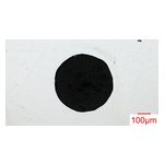
NIPPON KINZOKU startet Musterlieferung von „innenpolierten Kapillarrohren“ für Hochleistungs-Analyseinstrumente
TOKIO--(BUSINESS WIRE)--NIPPON KINZOKU CO., LTD. (TOKIO: 5491) (Hauptsitz: Minato-ku, Tokio) kündigt den Start eines Musterlieferungssystems für seine „Internally Polished Capillary Tubes“ (innenpolierten Kapillarrohre) an. Diese Rohre zeichnen sich durch eine deutlich verbesserte innere Oberflächenglätte bei extrem kleinen Abmessungen aus, was durch die Entwicklung einer unternehmenseigenen Innenpoliertechnologie erreicht wurde. Aktuell planen und bauen wir die Fertigungsanlagen und streben di...

-
Riassunto: NIPPON KINZOKU lancia una fornitura campione di tubi capillari con superficie interna lucidata per strumenti analitici ad alte prestazioni
TOKYO--(BUSINESS WIRE)--NIPPON KINZOKU CO., LTD. (TOKYO: 5491) (Headquarters: Minato-ku, Tokyo) annuncia il lancio di un sistema di fornitura di campioni dei suoi "Internally Polished Capillary Tubes" (tubi capillari con superficie interna lucidata) Questi tubi sono caratterizzati da una finitura interna altamente ottimizzata in dimensioni ultrasottili, realizzata grazie allo sviluppo della tecnologia proprietaria di lucidatura interna dell'azienda. Stiamo attualmente procedendo con la progetta...

-
Resumen: NIPPON KINZOKU comienza a suministrar muestras de «tubos capilares con pulido interior» para instrumentos analíticos de alto rendimiento
TOKIO--(BUSINESS WIRE)--NIPPON KINZOKU CO., LTD. (TOKIO: 5491) (Oficinas centrales: Minato-ku, Tokio) anuncia la primera fase de un sistema de suministro de muestras para sus «tubos capilares con pulido interior». Estos tubos presentan una suavidad interna significativamente mejorada en tamaños ultrapequeños, gracias al desarrollo de la tecnología de pulido interno patentada por la empresa. Actualmente estamos diseñando y construyendo los equipos de fabricación con el objetivo de iniciar la pro...

-
NIPPON KINZOKU lance la fourniture d’échantillons de « tubes capillaires à polissage interne » destinés aux instruments d’analyse haute performance
TOKYO--(BUSINESS WIRE)--NIPPON KINZOKU CO., LTD. (TOKYO : 5491), dont le siège social est situé à Minato-ku, Tokyo, annonce le lancement d’un système de fourniture d’échantillons pour ses « tubes capillaires à polissage interne ». Ces tubes présentent une surface interne nettement plus lisse, même dans des formats ultra-fins, grâce au développement de la technologie exclusive de polissage interne de l’entreprise. Nous poursuivons actuellement la conception et la mise en place des équipements de...
-
Samenvatting: NIPPON KINZOKU lanceert de levering van staaltjes 'vanbinnen gepolijste capillaire buizen' voor analyse-instrumenten met hoogwaardige prestaties
TOKIO--(BUSINESS WIRE)--NIPPON KINZOKU CO., LTD. (TOKYO: 5491) (hoofdzetel: Minato-ku, Tokio) kondigt de lancering aan van een systeem voor het leveren van staaltjes voor zijn 'vanbinnen gepolijste capillaire buizen'. De gladheid vanbinnen in deze buizen in de ultrakleine maten is aanzienlijk verbeterd, dankzij de zelf ontwikkelde technologie voor het vanbinnen polijsten. We werken momenteel aan het ontwerp en de bouw van productieapparatuur, met de bedoeling om in boekjaar 2027 in massaproduct...
