
")
")
")
")
")
")
")
")
")
")
")
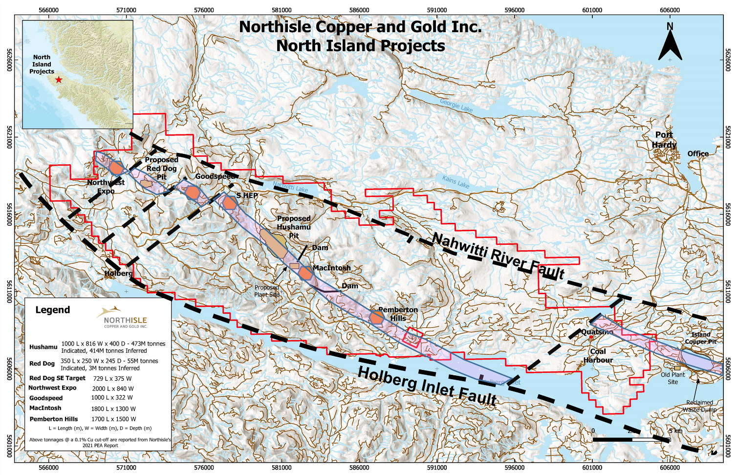
VANCOUVER, British Columbia--(BUSINESS WIRE)--Northisle Copper and Gold Inc. (TSX-V: NCX) (“Northisle” or the “Company”) is pleased to announce the results of its previously announced surface exploration program at the North Island Project (the “Project”). The program was a continuation of the work completed in early 2022 and covered the Pemberton Hills and Northwest Expo target areas, as well as the area between the Red Dog Deposit and the Goodspeed target plus the recently recognized Downward Dog target.
Multiple drill targets were identified at each of the survey areas which augment previous work and demonstrate attractive opportunities for further exploration during the 2023 field season and beyond. Of particular interest, the geophysical survey completed by Simcoe Geoscience in the Pemberton Hills area has identified coincident magnetic and chargeability signatures which are consistent with the existing data indicating the existence of a very large porphyry-style hydrothermal system with a more than 6km long lithocap visible at surface. Northisle has created a VRIFY deck which can be found at https://vrify.com/decks/12597-northisle-copper-and-gold-inc-pemberton-hills and provides a visual representation of the existing geological model at this highly prospective target.
Sam Lee, President and CEO of Northisle commented, “The results from the surface geophysical program completed during the fourth quarter have provided numerous drill targets for us to pursue during 2023 and beyond, and highlights the superb prospectivity of the 50km long porphyry belt on the North Island Project. 2023 is anticipated to be an exciting and busy year for our exploration team.”
Robin Tolbert, Vice President, Exploration added, “Coincident anomalies from surface mapping and sampling, historical geochemical surveys and recent geophysical programs provide confidence in our overall geological thesis and approach to exploring this extensive porphyry belt. I look forward to the start of the 2023 field season and the opportunity to drill test many of these exciting targets.”
Summary of Results
The fall 2022 program included approximately 55 line-kilometers of wireless ground induced polarization and magnetic surveys covering the Pemberton Hills, Northwest Expo, Red Dog, Downward Dog and Goodspeed targets. The survey commenced at Pemberton Hills on October 20, 2022 and concluded on December 4, 2022 with final reports received during January 2023.
Pemberton Hills
At Pemberton Hills, the geological model has evolved significantly since 2021, when four drill holes were completed in the lithocap occurring at the top of the Pemberton Hills porphyry system, which is now interpreted to be tilted approximately 30 to 50 degrees to the southwest (see Figure 2).
This reinterpretation is a result of the integration of the results of Northisle’s work with a previously confidential report completed by researchers from Lakehead University, the University of Tasmania’s Centre for Ore Deposits and Earth Sciences, UBC’s Mineral Deposit Research Unit and the BC Geological Survey. Utilizing this integrated model, theindications are that the core of the porphyry system is to the northeast of the location of previous work on the target.
As a result, Northisle specified a target area for geophysics (see Figure 3), which was anticipated to help identified the key subsurface structures which might support the overall thesis. The completed survey included a total of 23.55 line-kilometers covering an area of 4.4 km by 2.2 km.
Results from the geophysical survey, found in Figure 4 in context with surface alteration, are consistent with the surface geological mapping and reinterpretation. The report uses clay mineral and pyrite analysis, whole rock trace element ratios plus alteration mineral trace element ratios and fertility assessment, which provide key markers for vectoring towards the centre of hydrothermal upflow from the porphyry and are consistent with the conclusion that Pemberton Hills is a large and highly attractive target for exploration.
Fifteen preliminary targets have been defined by coincident high IP chargeability and magnetic susceptibility within or adjacent to the mapped quartz-white mica-pyrite alteration zone, of which five have been selected as near-term priority targets which will be permitted for work during 2023. The holes are planned to be oriented to drill through the high chargeability anomalies into the magnetic anomalies which are considered to be the most likely host of potential mineralization in the porphyry system.
Northwest Expo
At Northwest Expo (see Figure 5), the geophysical survey totaled 11.1 line-kilometres covering an area of 2.6 km by 1.0 km northeast of the Zone 1 area where Northisle carried out drilling in 2021 and identified a gold-enriched zone which is interpreted to be a portion of a larger porphyry system.
The objective of the geophysical survey was to test the area of the trend of silica-clay-pyrite alteration within which historic holes EC-236 intersected 176.4 metres @ 0.12% Cu, 0.09g/t Au and EC-242 intersected 91.5 metres @ 0.15% Cu, 0.18g/t Au. These intercepts are peripheral to a large chargeability anomaly to the west that has not been drill tested.
The geophysical survey defined 13 preliminary drill targets in addition to the Zone 1 area to be drilled (Figure 6). Eight of the targets are within the untested area of high chargeability (>12mV/V) noted above.
Red Dog/Goodspeed
At Red Dog and Goodspeed, a geophysical survey totalling 15.79 line-kilometres was completed over an area of 3,500m by 850m from the Red Dog deposit (see Figure 7) extending east to Goodspeed, where a stockwork of chlorite-magnetite alteration (CMG) containing chalcopyrite-bornite mineralization occurs at surface (see Figure 8), and four historic, shallow drill holes intersected significant copper mineralization (see Table 1).
Recent structural mapping at Goodspeed has outlined a large area of silica-clay-pyrite (SCP) alteration with a 500m by 350m core of CMG alteration containing quartz-magnetite veining and minor chalcopyrite-bornite. The CMG alteration and copper mineralization is analogous to other known occurrences in the area, and historical drilling in the 1960s and 1990s intersected encouraging copper values.
Table 1: Selected Significant Intercepts from Historical Goodspeed Drilling
DDH |
UTM_E |
UTM_N |
Azimuth |
Dip |
Length (m) |
From (m) |
To (m) |
Intercept (m) |
Copper (%) |
EC-119* |
574401 |
5617878 |
224 |
-45 |
157.3 |
* |
* |
* |
* |
EC-194 |
574716 |
5617574 |
0 |
-45 |
126.5 |
6 |
30 |
24.0 |
0.135% |
EC-195 |
574716 |
5617574 |
0 |
-90 |
49.4 |
9 |
36 |
27.0 |
0.188% |
EC-197 |
574570 |
5617654 |
3 |
-45 |
105.2 |
12 |
84 |
72.0 |
0.192% |
* EC-119 was reported as containing 24m of 0.32% Cu in a report by Equity Engineering Ltd. in April 2006. The collar data has been confirmed but the depth of the interval has not yet been verified.
The Red Dog/Goodspeed geophysical survey confirmed an eastward extending chargeability anomaly from Red Dog to Goodspeed (see Figure 9) which is consistent with the extent of the silica-clay-pyrite alteration observed at surface. Eight preliminary targets for drill testing have been defined.
Downward Dog
At Downward Dog, an IP/magnetic geophysical survey was carried out along two forest service roads (brown dashed lines in Figure 9), to test a prospective area identified by a review of historic geophysics and soil geochemistry adjacent to a previous geophysical survey which did not fully cover the area (See Figure 10).
The results of that survey (Figure 11) showed coincident chargeability and magnetic anomalies in the area of the coincident soil geochemical anomalies noted above. Previous drill holes, including Northisle’s 2021 drill hole RD21-02, were either drilled away from the coincident geophysical anomalies, were too short or did not penetrate overburden.
Five preliminary targets have been defined for future drill testing.
Qualified Person
Robin Tolbert, P.Geo., Vice President Exploration of Northisle and a Qualified Person as defined by National Instrument 43-101 – Standards of Disclosure for Mineral Projects, has approved the scientific and technical disclosure contained in this news release.
About Northisle
Northisle Copper and Gold Inc. is a Vancouver-based company whose mission is to become Canada’s leading sustainable mineral resource company for the future. Northisle owns the North Island Project, which is one of the most promising copper and gold porphyry deposits in Canada. The North Island Project is located near Port Hardy, British Columbia on a more than 34,000-hectare block of mineral titles 100% owned by Northisle stretching 50 kilometres northwest from the now closed Island Copper Mine operated by BHP Billiton. Northisle completed an updated preliminary economic assessment for the North Island Project in 2021 and is now focused on advancement of the project through a prefeasibility study while continuing exploration within this highly prospective land package.
For more information on Northisle please visit the Company’s website at www.northisle.ca.
Cautionary Statements regarding Forward-Looking Information
Certain information in this news release constitutes forward-looking statements under applicable securities law. Any statements that are contained in this news release that are not statements of historical fact may be deemed to be forward-looking statements. Forward-looking statements are often identified by terms such as “may”, “should”, “anticipate”, “expect”, “intend” and similar expressions. Forward-looking statements in this news release include, but are not limited to, statements relating to outcome of exploration programs as well as any other future plans, objectives or expectations of Northisle. Forward-looking statements necessarily involve known and unknown risks, including, without limitation, Northisle’s ability to implement its business strategies; risks associated with mineral exploration and production; risks associated with general economic conditions; adverse industry events; stakeholder engagement; marketing and transportation costs; loss of markets; volatility of commodity prices; inability to access sufficient capital from internal and external sources, and/or inability to access sufficient capital on favourable terms; industry and government regulation; changes in legislation, income tax and regulatory matters; competition; currency and interest rate fluctuations; and other risks. Readers are cautioned that the foregoing list is not exhaustive.
Readers are further cautioned not to place undue reliance on forward-looking statements as there can be no assurance that the plans, intentions, or expectations upon which they are placed will occur. Such information, although considered reasonable by management at the time of preparation, may prove to be incorrect and actual results may differ materially from those anticipated. Forward-looking statements contained in this news release are expressly qualified by this cautionary statement.
The forward-looking statements contained in this news release represent the expectations of management of Northisle as of the date of this news release, and, accordingly, are subject to change after such date. Northisle does not undertake any obligation to update or revise any forward-looking statements, whether as a result of new information, future events or otherwise, except as expressly required by applicable securities law.
Neither the TSX Venture Exchange nor its Regulation Services Provider (as that term is defined in the policies of the TSX Venture Exchange) accepts responsibility for the adequacy or accuracy of this news release.