
")
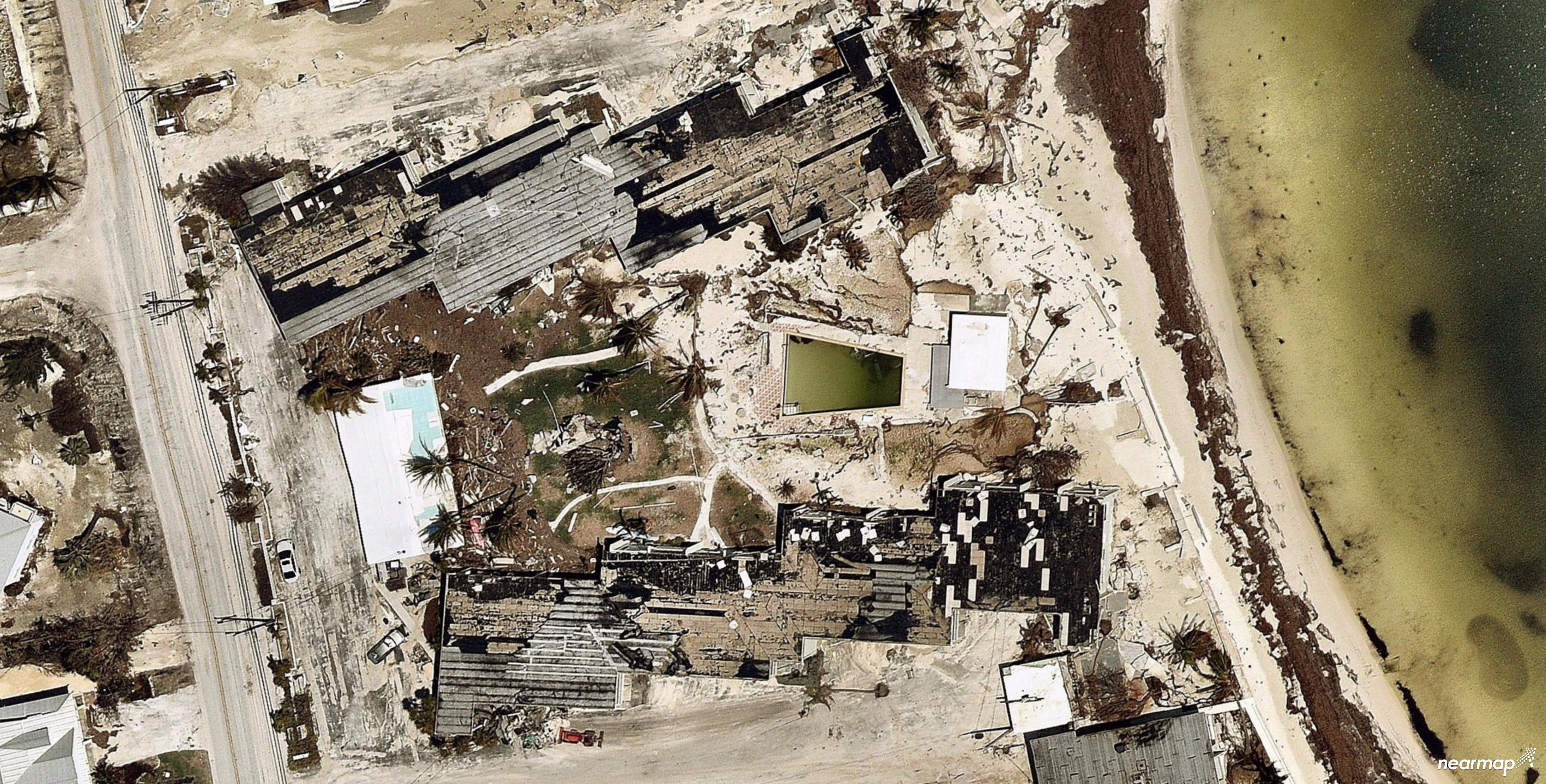
SOUTH JORDAN, Utah--(BUSINESS WIRE)--Nearmap, a location content provider specializing in high-resolution, aerial maps, has flown and captured the devastation in Southwest Florida caused by Hurricane Irma. This imagery has the potential to aid in emergency response and rescue, homeland security and local law enforcement, flood management, emergency fund allocation, utility and electric support as well as the insurance and claims industry.
Nearmap deployed aircraft with its proprietary camera system to the affected areas around Naples, Fort Meyers and Cape Coral as well as the Florida Keys—from Key West, the Lower and Middle Keys. The aerial maps were captured and processed on Sept. 13-17, 2017, and were released this week.
Local, state and federal agencies have responded rapidly in support of citizens in need of emergency medical care, shelter, water, food and supplies. Nearmap aerial imagery assists in those efforts in the following ways:
- Emergency Response and Rescue – Aerial captures can be used to navigate first responders and 911 emergency services as well as to analyze road conditions.
- Homeland Security and Police Services – Law enforcement can see what area is most affected—making it more susceptible to unlawful activity. Police can send help and resources to that area to prevent crime.
- Flood Management Analysis – Aerial photos can be used to measure the impact of the flooding and to analyze the physical and environmental ramifications.
- Emergency Fund Allocation – FEMA and disaster relief agencies can know the extent of devastation in an area to make quick, informed decisions about how money is allocated.
- Utility and Energy Support – Utility and telecom companies can be informed where power lines have fallen and respond quickly for the safety of citizens.
- Insurance and Claims Management – With historical data provided by Nearmap's previous captures, insurers can compare before and after shots to expedite the claims process and give families the funds they need.
Nearmap has always captured at sub 3” GSD, making Nearmap aerial photography several times sharper than satellite, with better color and fidelity. Where a satellite image may show the general dimensions of a roof, aerial mapping clearly shows its vents, skylights and other detailed features. The same is true for streets and all other ground features, providing details for users to complete analysis both pre and post storms. With HyperCamera2, the resolution has improved to 2.2” GSD, creating even finer detail.
“Our thoughts are with the residents of Florida and Texas recently impacted by hurricanes. Our imagery can support efforts to rebuild infrastructure, restore power and guide insurance agencies in the recovery efforts,” said Patrick Quigley, Nearmap senior vice president and general manager—U.S. “Users rely on Nearmap’s consistent capture model, which delivers imagery within days of capture. This provides a historical record, so users can view changes over time from as early as 2014.”
Nearmap also recently captured areas of Texas affected by Hurricane Harvey. Imagery of areas affected by both Harvey and Irma can be accessed through the Nearmap MapBrowser viewer and WMS, WMTS and TMS API for seamless integration with Esri, AutoCAD and custom GIS Applications.
About Nearmap
Nearmap brings the real world to you. We capture, manage and deliver the most current location content in the world, allowing businesses and governments to explore their environment easily. With Nearmap, organizations unlock opportunities that consistently inform decision-making and transform the way they work. Our high-resolution, frequently updated aerial imagery is 2.8-inch GSD, better than satellite imagery. Delivered within days of capture, Nearmap shows changes over time. Users save time and money, reduce site visits and efficiently plan with current, clear imagery.
Nearmap is delivered through a refreshingly easy-to-use interface called MapBrowser™ or accessed via Esri® and Autodesk products.
Free trials of Nearmap are available. For more information, visit http://go.nearmap.com.