
")
")
")
")

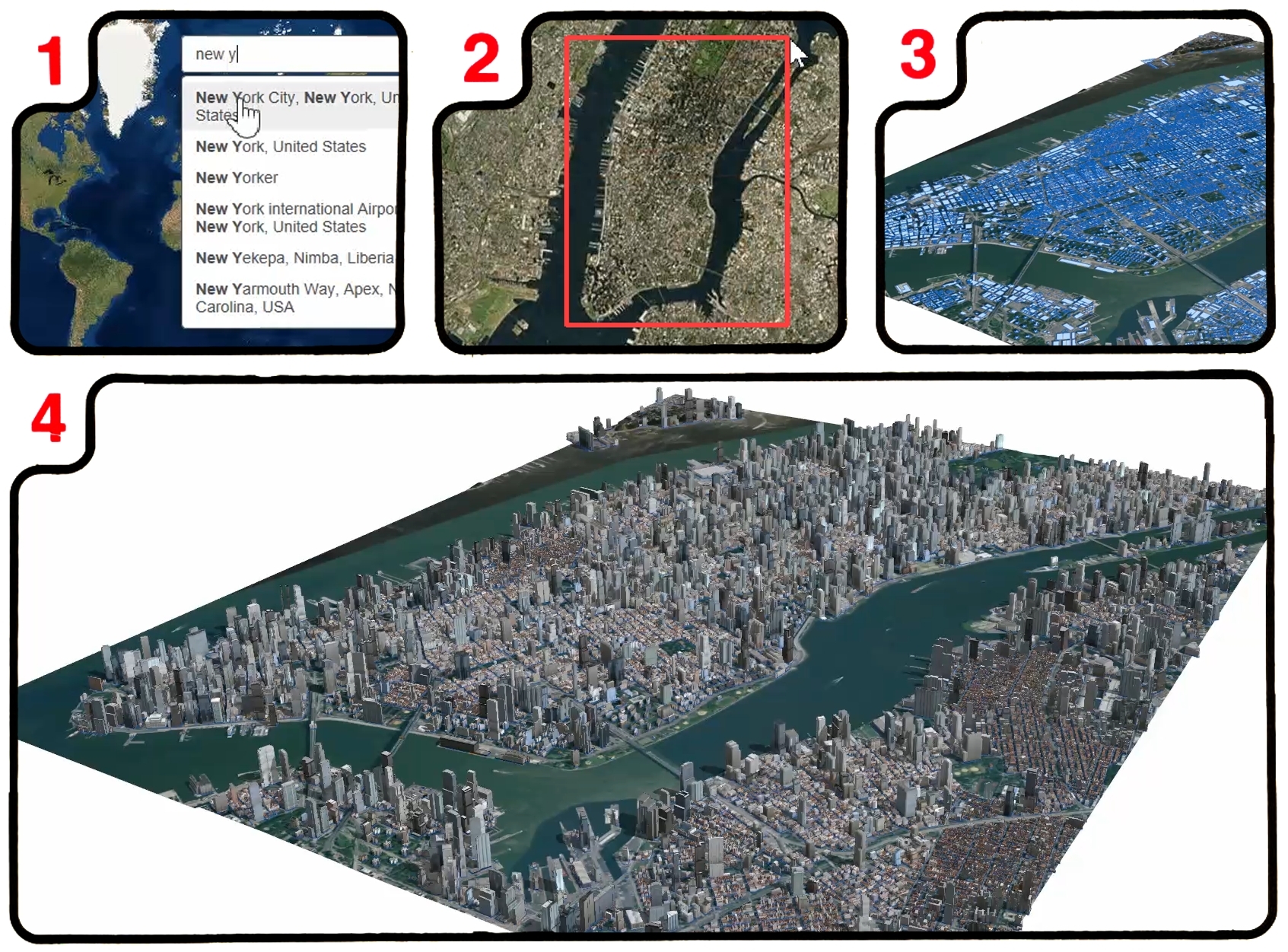
REDLANDS, Calif.--(BUSINESS WIRE)--Esri, the global leader in geographic information system (GIS) solutions, today announced the release of Esri CityEngine 2016. This revolutionary modeling technology allows GIS professionals, 3D artists, architects, and urban planners to create smart 3D city models in a matter of minutes. With just a few clicks, the new Get Map Data interface will import satellite imagery, 3D terrain, and street data from any city in the world. What was once a very complicated and time-intensive process now can be done quickly and simply.
"This release integrates CityEngine with Esri's powerful ArcGIS platform," said Pascal Mueller, director of the Esri R&D Center, Zurich. "We created a simple way to import real-world elevation data and basemaps from ArcGIS Online. We have also introduced support for Esri's new 3D streaming services with scene layer packages [.SPKs]. Scene layers can be hosted in the cloud and viewed using ArcGIS Scene Viewer, a browser-based application for viewing 3D content at any scale and with unlimited extent."
Another highly requested feature that's included with CityEngine 2016 is the Alembic exporter. The Alembic format is used by visual effects and animation professionals and is well-suited to handling massive 3D models. It is now possible to batch generate tens of thousands of building geometries at the highest level of detail and visualize them in a renderer without needing a complicated production pipeline.
"CityEngine has clearly become the standard for designing high-quality, large-scale 3D cities in feature films. It has proved itself again as an invaluable tool during the demanding production of Independence Day: Resurgence," said CityEngine expert Matthias Buehler, founder of vrbn (vrbn.io), former ScanlineVFX environment developer lead and Gnomon Workshop instructor. "CityEngine 2016 impresses with major new features: The Alembic exporter allows for an efficient integration of CityEngine in state-of-the-art VFX pipelines, while Get Map Data provides an excellent tool to load real-world, georeferenced satellite imagery, terrain, and streets directly from the web into CityEngine for quick design iterations of shot layouts."
Find more information and technical details by visiting the What's New in CityEngine web page.
CityEngine 2016 is available for Windows, Mac, and Linux platforms. A free 30-day trial with full export capabilities can be downloaded at go.esri.com/prfreetrial.
About Esri
Since 1969, Esri has been giving customers around the world the power to think and plan geographically. As the market leader in GIS technology, Esri software is used in more than 350,000 organizations worldwide including each of the 200 largest cities in the United States, most national governments, more than two-thirds of Fortune 500 companies, and more than 7,000 colleges and universities. Esri applications, running on more than one million desktops and thousands of web and enterprise servers, provide the backbone for the world's mapping and spatial analysis. Esri is the only vendor that provides complete technical solutions for desktop, mobile, server, and Internet platforms. Visit us at esri.com/news.
Copyright © 2016 Esri. All rights reserved. Esri, the Esri globe logo, GIS by Esri, ArcGIS, esri.com, and @esri.com are trademarks, service marks, or registered marks of Esri in the United States, the European Community, or certain other jurisdictions. CityEngine is a registered trademark of Esri R&D Center Zurich AG and is distributed under license by Esri. Other companies and products or services mentioned herein may be trademarks, service marks, or registered marks of their respective mark owners.
