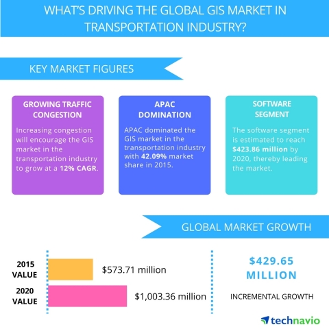
LONDON--(BUSINESS WIRE)--Technavio’s latest research report on the global geographic information system (GIS) market in the transportation industry provides an analysis on the most important trends expected to impact the market outlook from 2016-2020. Technavio defines an emerging trend as a factor that has the potential to significantly impact the market and contribute to its growth or decline.
Ishmeet Kaur, a lead analyst from Technavio, specializing in research on product lifecycle management sector says, “The GIS market will grow at a steady rate during the forecast period. The increased use of GIS for traffic management, airport construction, and asset maintenance in ports will lead to the market growth.”
Request a sample report: http://www.technavio.com/request-a-sample?report=54913
Technavio’s sample reports are free of charge and contain multiple sections of the report including the market size and forecast, drivers, challenges, trends, and more.
The top three emerging market trends driving the global GIS market in the transportation industry according to Technavio ICT research analysts are:
- Increasing integration of GIS with social networks
- Increasing demand for 3D GIS software and development of 4D GIS software
- Increasing demand for industry-specific GIS
Increasing integration of GIS with social networks
Many retailers use GIS technology to enhance their marketing campaigns over social networks. Vendors use GIS applications to get demographic details of target customers, which help retailers to promote their campaigns on social networks. Retailers post updates and offers through social networks based on the information collected from GIS software.
With the increase in the number of smartphone users, this trend will result in significant growth during the forecast period. China and India are among the top consumers of smartphones in the world. The smartphone users are the GIS data generators, and companies such as Amazon and Google retain this data in large cloud infrastructure. The retained data is further processed, and the information is provided to the companies.
Increasing demand for 3D GIS software and development of 4D GIS software
The growing use of GIS for security applications is resulting in increased development of 3D GIS software. The 3D GIS software provides better visibility and performance than 2D GIS software.
“Many end-users, especially the government and defense organizations, have started adopting 3D GIS software to improve the operational efficiency of their security applications,” says Ishmeet.
Also, vendors are focusing on the development of 4D GIS software. 4D GIS data includes 2D data, 3D data, and data regarding time change. An integrated database with real-time monitoring is required to generate 4D data. Companies have started providing support for 4D data. For instance, 4DMapper is an Australia-based company that puts multi-source and multi-format geospatial data, including 3D and 4D GIS, on the cloud and streams it to browsers after rasterization and vectoring.
Increasing demand for industry-specific GIS
The vendors in the GIS market in APAC provide customized GIS applications as per the industry requirements. For instance, the retail industry vendors opt for customized GIS solutions to suit their requirements. This helps them remain competitive in the market.
In addition, vendors develop application-specific GIS solutions, which are in high demand among retailers as they are more cost-effective than general purpose GIS solutions. For instance, TransCAD, a GIS software developed by Caliper Corporation, is designed for managing, analyzing, and displaying transportation data. The software combines GIS with transportation modeling to form a single integrated platform.
Browse Related Reports:
- Global Geographic Information System Analytics Market 2016-2020
- Geographic Information System Market in BRIC Countries 2016-2020
- Geographic Information System Market in Asia-Pacific 2016-2020
Do you need a report on a market in a specific geographical cluster or country but can’t find what you’re looking for? Don’t worry, Technavio also takes client requests. Please contact enquiry@technavio.com with your requirements and our analysts will be happy to create a customized report just for you.
About Technavio
Technavio is a leading global technology research and advisory company. The company develops over 2000 pieces of research every year, covering more than 500 technologies across 80 countries. Technavio has about 300 analysts globally who specialize in customized consulting and business research assignments across the latest leading edge technologies.
Technavio analysts employ primary as well as secondary research techniques to ascertain the size and vendor landscape in a range of markets. Analysts obtain information using a combination of bottom-up and top-down approaches, besides using in-house market modeling tools and proprietary databases. They corroborate this data with the data obtained from various market participants and stakeholders across the value chain, including vendors, service providers, distributors, re-sellers, and end-users.
If you are interested in more information, please contact our media team at media@technavio.com.


